
Project Background
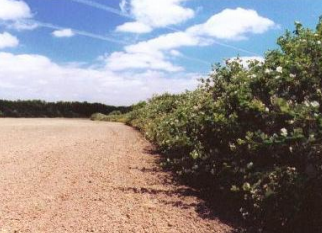 Pre-project (2001): Blackberry dominated the riparian areas of the historic channel of Coyote Creek.[/caption]
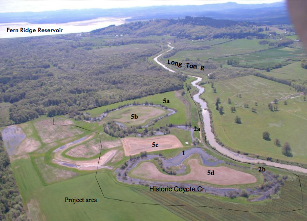
This project is located on a 140-acre parcel approximately 2.5 miles north of Fern Ridge Reservoir. Prior to the Army Corps of Engineers channelizing the Long Tom River in the 1940’s, the confluence of the Long Tom River and Coyote Creek was located in the northwestern portion of the property.
This area flooded regularly in the winter before the Corps constructed Fern Ridge Reservoir and channelized the river. Channelization and loss of streamside vegetation has contributed to the loss of slow-moving backwater areas that once provided habitat for Oregon chub. The disconnection between Coyote Creek and the Long Tom River has also decreased winter refuge for fish seeking to escape the intense, high flows of the Long Tom River.
Surveyors in the mid 1800s described the area as containing lowland wet prairie with sloughs and swales, and the upland portions containing primarily oak and ash trees interspersed with Ponderosa pine. Beginning in the early 1900’s, previous landowners farmed and grazed over half of the property.
The current landowner began working with the Council and US Fish & Wildlife Service in 2001 to restore the property for fish and wildlife habitat. Segments of the historic channel had been isolated by previous agricultural activities and the native riparian vegetation had largely been replaced by invasive Himalayan blackberry. Also, the historic upland prairie had been converted into farmland.
Restoration Techniques
- We removed fill from previous agricultural activities that disconnected the historic channel. (See upper photo to right and 1 on aerial photo.)
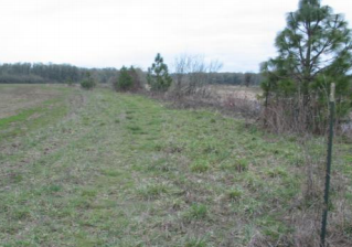
- We installed stop logs on two culverts draining the channel to allow water to stay until late June. This provides sufficient time for native amphibians to hatch and leave the water (See lower photo to right and 2a and 2b on aerial photo).
- Invasive blackberry that lined the riparian areas of historic Coyote Creek was mowed, piled and burned. Re-growth was sprayed with herbicide.
Several rounds of mowing and spot spraying were required to eradicate the well established blackberry. - Native trees and shrubs were planted along the entire length of historic Coyote Cr. where it flows through farmed area (foreground in aerial photo).
- Some of the farmed fields were restored to upland prairie. This involved several rounds of herbicide application to eradicate non-native grasses and
forbs followed by no-till drilling with native grasses and forbs. (See 5a, b, c, & d on aerial).
Environmental and Economic Benefits
- The removal of non-native blackberry in the riparian area has provided space for a diversity of native trees and shrubs. These natives provide better nesting habitat and food for native birds, amphibians, and reptiles. Ultimately the mature riparian corridor will shade the stream and provide cover for many native mammals.
- Before the stop-logs were installed, the historic channel dried out in early May. Consequently, native amphibians did not have time to hatch and mature to their terrestrial stage before the water dried up. Now the water remains long enough to provide native amphibian breeding habitat. We have also seen western pond turtle basking in the channel since the hydrologic improvement.
- An estimated 99% of native prairie has been lost in the Willamette Valley from presettlement times. Consequently, many of the plant and animal species associated with these habitats have become threatened or endangered, including Bradshaw’s lomatium, Willamette daisy, Kincaid’s lupine, and Fender’s blue butterfly. Restoration of the upland prairie at this site will benefit species such as Western meadowlark, Western blue bird, and a host of other native birds and butterflies.
- Contractors from the surrounding area were hired for all phases of the project, helping to boost the local economy
Project Funding & Partners
Project Cost
$86,056
Funding:
OWEB Grants: $26,754
USFWS: $35,959
Landowner Match: $23,343
Partners
Oregon Watershed Enhancement Board
Art Johnson, Landowner
US Fish & Wildlife Service